06 / GIS & Satellite Intelligence

The planet,monitored weekly.

Bear Systems delivers enterprise-grade satellite intelligence — multi-source imagery enhanced to 75cm, physics-based analytics with a zero-hallucination guarantee, and continuous monitoring across 16 industries. Ten years of archive. Refresh cycles as fast as hourly. Any location on Earth.
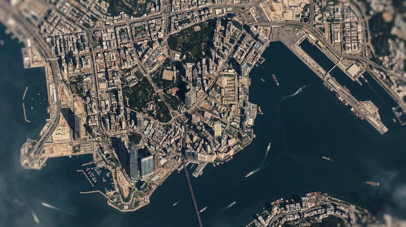
AI-enhanced 1m true-color satellite image of a coastal city — Bear Systems Refined Reality visual imageryRefined Reality · 1m visualRefresh 2–5 daysArchive 2015 →Zero hallucinations · physics-based
75cm
Finest enhanced resolution
Hourly
Fastest basemap refresh
2015 →
Worldwide archive
16
Industries served
01 — Imagery Portfolio8 data products · multi-source
1m
Refined Reality Visual
Twice-weekly true-color enhanced by physics + ML sharpening. 50cm super-resolution available. Zero hallucinations, source-grade geolocation.
Refresh2–5 days
Archive2015 →
75cm
Daily Visual
Daily optical data refined to 1.9m visual, with 1.5m and 75cm super-resolution rendered in real time — daily and archive alike.
RefreshDaily
Archive10 years
2m
SAR Radar
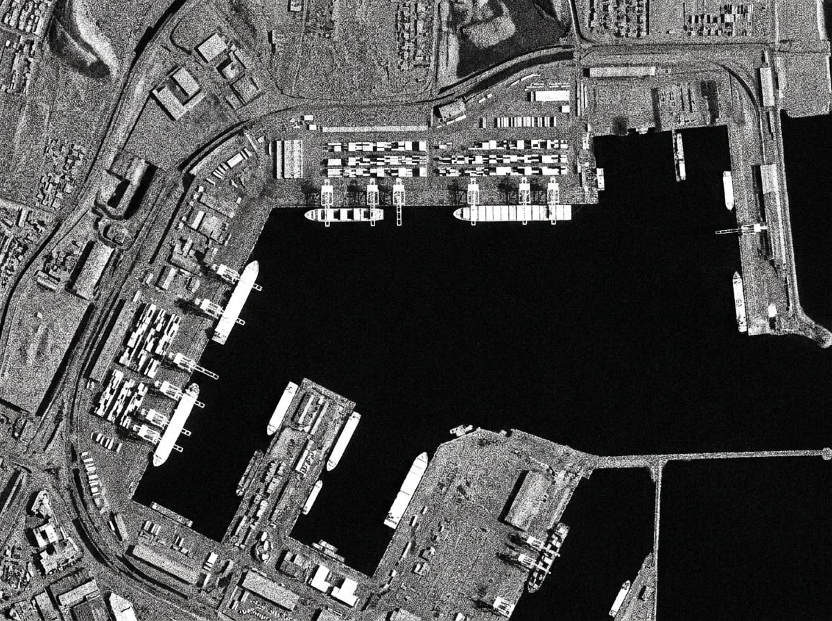
Sees through clouds, day or night. VV and VH polarisation provided at 1m, covering land, seas, and main shipping routes.
Refresh6 days
Archive10 years
2–4m
Enhanced Multispectral
10 bands including 2 SWIR. NDVI, NBR, water and moisture indices with best-in-class scientific calibration. Physics-based only.
Refresh2–5 days
Bands10 · 2 SWIR
2.5m
Live Basemap
Worldwide basemap refreshed hourly as new data lands — Latest Usable and Latest Change layers, plus quarterly cloudless composites.
RefreshHourly
CoverageWorldwide
1m
Elevation Model
BaseDEM with 0.5–1m vertical accuracy — independently verified within 1m of LiDAR. Drives flood, terrain, and line-of-sight analysis.
Vertical0.5–1m
DeliveryOne-time
25m
Nightlight
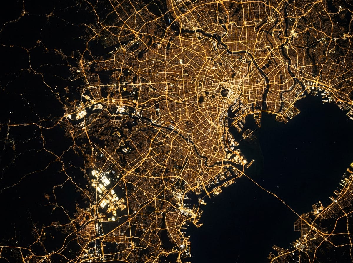
Nightly worldwide update from super-resolved NASA Black Marble. Tracks power outages and the growth or decline of industrial areas.
RefreshNightly
SourceVIIRS
5cm
Aerial
Government-agency aerial imagery across 20+ countries — France 20cm, Spain 11cm, Switzerland 10cm, New Zealand to 1cm — some refreshing continuously.
Coverage20+ countries
Best1–5cm
SAR radar satellite image of a seaport — vessels as bright radar returns, captured through cloud cover
SAR 2m — through clouds, day or night
Sentinel-1 enhanced · 6-day revisit
Nighttime satellite view of city lights — VIIRS nightlight data tracking urban and industrial activity
Nightlight 25m — activity after dark
VIIRS · nightly worldwide update
02 — Analytics & Monitoring9 solutions · 3 patent-pending
A1

Flood Simulation

Water reach, modelled on sub-metre terrain.

Simulate inundation from any water height at your area of interest, on an elevation model accurate to 0.5–1m vertically — then verify actual flood reach against 1m visual imagery. Proven from Miami to Jakarta.

  • Terrain-accurate reach modelling at any flood height
  • Drainage and low-lying area identification for planning
  • Post-event verification against 1m visual imagery
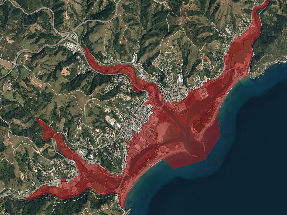
Satellite flood simulation with red inundation-extent overlay on a coastal town, modelled on 1m elevation dataFLOOD EXTENT · +2.0M ASLBASEDEM · 0.5–1M VERTICAL
A2Patent-pending

Early In-Field Anomalies

Field stress, caught before the eye can see it.

A universal signal for classic agricultural issues: each field is tracked against its own behaviour to flag stunted growth from pest and disease stress, or unexpected local growth like weeds — at 2m, every 2–5 days.

  • Pest, disease, and weed stress detected early at field level
  • Soil moisture and salinity indices down to irrigation lines
  • Grassland biomass in t/ha with 90%+ correct field ranking
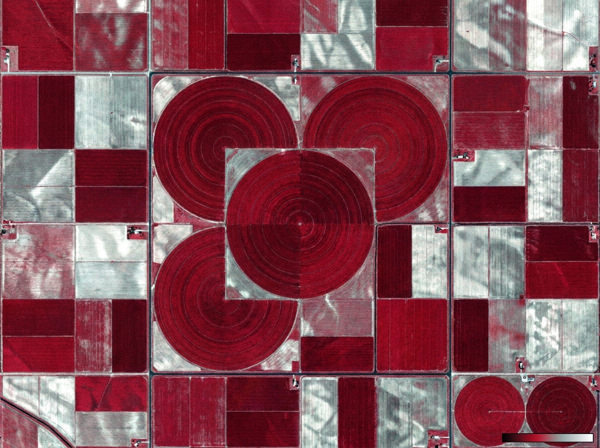
False-color NDVI multispectral satellite view of centre-pivot irrigation fields showing crop health at 2m resolutionNDVI · 2M MULTISPECTRALREFRESH 2–5 DAYS
A3

Mining Monitoring

Every pit on the planet, checked weekly.

Worldwide detection of new, retired, and active mining between any two dates — updated with every cloud-free capture, up to every 2.5 days. 100% accurate ground-truth identification across 7 mining types and 6 mineral groups.

  • New, retired, and still-active sites between any two dates
  • Pit, dump, and stockpile progression with volume estimates
  • Tailings dams, runoff, and encroachment under weekly watch
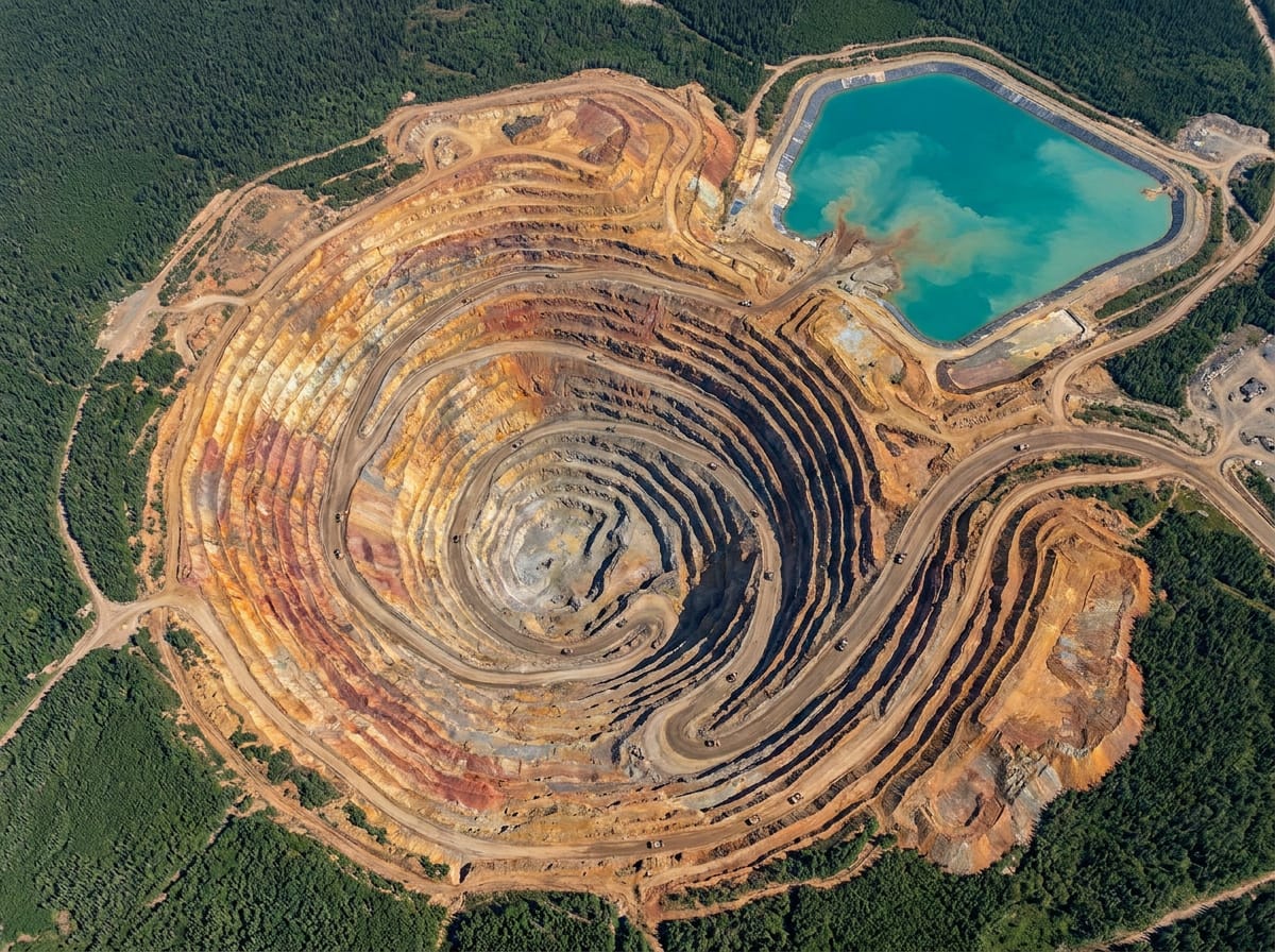
Overhead satellite image of an open-pit mine with terraced benches, monitored weekly for change detectionCHANGE CAPTURE · WEEKLYGROUND TRUTH · 100%
Mineral Map
2–4m multispectral surveys revealing alteration signatures invisible at 10–20m — six classifications from hematite to propylitic, full time series from archive.
Water Leak WarningsPatent-pending
Nation-scale detection of likely underground leaks from weekly localized soil-moisture anomalies at 2m — layered beneath your pipe network.
GLOF MonitoringPatent-pending
Glacial lake outburst floods: automatic lake baselining, outburst volume estimates, moraine-break analysis, and projected outflow paths on 1m elevation.
Soil Moisture & Salinity
Composite moisture index robust across conditions; salinity scored 0–100 at 2m for early detection — even along irrigation lines. Wetland and peatland drainage included.
Fire Hazard & Recovery
Dry-vegetation monitoring, active-fire see-through via SWIR, burn-rate deltas, erosion risk on baked terrain, and time-to-recovery projections.
Grassland Biomass
Tonnes per hectare, auto-calibrated to geography with ±15–20% relative accuracy between fields — built for the next grazing decision.
03 — Sixteen IndustriesSelect an industry · applications at right
01 · Always-current situational awareness

Defence & Intelligence

  • Persistent area surveillance
  • Base and facility monitoring
  • Border and crossing activity
  • Terrain and route planning
  • Pre/post strike assessment
  • Force deployment awareness
  • Maritime and port activity
  • Infrastructure vulnerability
  • Population movement tracking
  • Allied imagery sharing
10 applications · imagery + analytics scoped per AOI
04 — Access ModelView · Download · API · Data delivery
Yearly Subscription
Continuous imagery access, priced per km² or hectare of your area of interest.
  • 1m Visual · 75cm Daily Visual
  • Enhanced Multispectral + indices
  • SAR 2m · Basemap 2.5m
  • Nightlight · Aerial (20+ countries)
One-Time Data
Single-delivery datasets for engineering, exploration, and baseline work.
  • Elevation Map & 3D BaseDEM
  • Mineral Map surveys
  • Quarterly cloudless basemaps
  • Historical archive extracts (2015 →)
Annual Monitoring
Managed detection services — we watch your AOI and deliver the signal.
  • Water leak warnings
  • GLOF outburst monitoring
  • In-field crop anomalies
  • Mining change detection
Pricing structure per km² or hectare · final values defined per AOI scope and contract term · full archive since 2015 included for historical comparison
Start With Your Area of Interest
Tell us where to look. We'll show you what we see.
Tailored capability demonstration
Send us your AOI — we respond with sample imagery and the analytics that fit your use case.
Scoped to your terrain
Subscriptions priced per km² or hectare. Monitoring services scoped per AOI and contract term.
Ten years of hindsight, included
Every engagement includes the archive since 2015 — see what your site looked like before you asked.
Request a Capability Demonstration
Full name
Business email
Company / Organization
Area of interest
Message